Digital Analysis Using Satellite Images (Remote Sensing Only)
General Description:
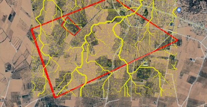
This service involves analyzing satellite images to identify potential areas for groundwater presence. This analysis is based on the use of remote sensing, which allows examination and measurement of soil characteristics from satellite data.
Based on this data, a detailed report is provided, including digital maps of the targeted areas, with an initial estimate of groundwater presence and expected drilling depth.
Benefits:
- High accuracy: The analysis relies on satellite data that provides comprehensive and reliable information about topography, land use, and geographic areas likely to contain groundwater.
- Low cost: No on-site visits or specialized equipment are required, making the service more affordable for clients.
- Quick execution: Satellite analysis can be completed faster than field surveys, allowing clients to receive results more promptly.
- Suitable for preliminary projects: Helps provide an initial assessment of the site, making it easier to decide whether to continue or expand the study.
- Versatility: This service is applicable to a wide range of projects (less than 5 hectares or more), as it is based on data that can be customized based on area size.
Detailed Process of the Service:
- Data Collection:
-
- We begin by collecting available satellite images for the target location.
- These images are analyzed to gather information about topography, hydrology, and vegetation, indicating the likelihood of groundwater presence in the area.
- Data Analysis:
-
- Analyzing the geographical and topographical data extracted from the satellite images.
- Using Geographic Information System (GIS) software to extract information about soil characteristics and water resources.
- Report Preparation:
-
- A detailed PDF report is generated that includes:
- Digital Maps showing potential drilling points based on the geographic analysis.
- An estimate of water depth based on soil characteristics and geographic location.
- A comprehensive description of the targeted site and its geological features.
- An estimate of feasibility for groundwater exploration in the area.
- A detailed PDF report is generated that includes:
- Delivery:
-
- The report is delivered to the client in the form of a PDF file, containing all the data and information, along with KML maps for use in Geographic Information Systems (GIS).
Main Deliverables:
- Detailed PDF Report: Includes all information and recommendations based on the digital analysis.
- Digital Maps (KML): Allowing the client to view target points in Geographic Information Systems (GIS).
- Depth Estimation: A preliminary estimate of groundwater depth in the targeted areas.
- Estimated Accuracy: Evaluation of the accuracy of the results based on the data used.
Pricing:
- Our services start from 100 USD
(Prices may vary depending on the type of images used and the size of the targeted area)
Recommendation:
This service is ideal for clients who want to get a preliminary assessment of the site without heavy investment or the need for on-site visits. It can be used for smaller projects or as the first step before